


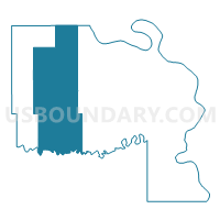
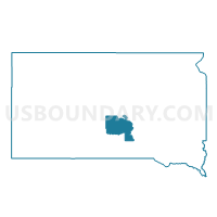
VTD-precinct 12 Presho, Lyman County, South Dakota
About
Outline

Summary
| Unique Area Identifier | 667506 |
| Name | VTD-precinct 12 Presho |
| County | Lyman County |
| State | South Dakota |
| Area (square miles) | 376.19 |
| Land Area (square miles) | 375.17 |
| Water Area (square miles) | 1.02 |
| % of Land Area | 99.73 |
| % of Water Area | 0.27 |
| Latitude of the Internal Point | 43.92700300 |
| Longtitude of the Internal Point | -100.11604510 |
Maps

Graphs
Select a template below for downloading or customizing gragh for VTD-precinct 12 Presho, Lyman County, South Dakota


Neighbors
Neighoring Voting District (by Name) Neighboring Voting District on the Map
- VTD-Ideal precinct, Tripp County, SD
- VTD-precinct 13 Vivian, Lyman County, SD
- VTD-precinct 2, Stanley County, SD
- VTD-precinct 9 Kennebec, Lyman County, SD
- VTD-Witten precinct, Tripp County, SD
Top 10 Neighboring County Subdivision (by Population) Neighboring County Subdivision on the Map
- Lower Brule UT, Lyman County, SD (1,481)
- Presho city, Lyman County, SD (497)
- South Stanley UT, Stanley County, SD (469)
- West Lyman UT, Lyman County, SD (230)
- Vivian township, Lyman County, SD (146)
- Star Valley township, Tripp County, SD (30)
- Rose township, Lyman County, SD (25)
- Lower Brule UT, Stanley County, SD (24)
- Pratt township, Lyman County, SD (16)
- Pahapesto UT, Tripp County, SD (9)
Top 10 Neighboring Place (by Population) Neighboring Place on the Map
Top 10 Neighboring Unified School District (by Population) Neighboring Unified School District on the Map
- Winner School District 59-2, SD (4,660)
- Lyman School District 42-1, SD (2,974)
- Stanley County School District 57-1, SD (2,966)
- Colome Consolidated School District 59-3, SD (1,212)
Top 10 Neighboring State Legislative District Lower Chamber (by Population) Neighboring State Legislative District Lower Chamber on the Map
- State House District 24, SD (21,361)
- State House District 21, SD (21,057)
- State House District 26B, SD (9,915)
Top 10 Neighboring State Legislative District Upper Chamber (by Population) Neighboring State Legislative District Upper Chamber on the Map
- State Senate District 26, SD (21,575)
- State Senate District 24, SD (21,361)
- State Senate District 21, SD (21,057)
Top 10 Neighboring 111th Congressional District (by Population) Neighboring 111th Congressional District on the Map
Top 10 Neighboring Census Tract (by Population) Neighboring Census Tract on the Map
- Census Tract 9601, Stanley County, SD (2,966)
- Census Tract 9726, Lyman County, SD (2,275)
- Census Tract 9716, Tripp County, SD (2,261)
- Census Tract 9401, Lyman County, SD (1,480)